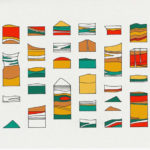
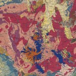
The online archive of the United States Department of the Interior Geological Survey is a valuable resource filled with detailed three-dimensional territorial maps employing various representational techniques.
Thanks to the work of artist, designer, and developer Jill Hubleys and their dedicated ‘X’ page, we’ve uncovered numerous isometric diagrams. Handpicked here, are a selection of them, including categories such as “Isometric Fence Diagrams”, “Isometric Cross-Section Diagrams”, and “Isometric Block Diagrams”.